Taiwan 921 Disaster Damage Drill and Discussion held with International Partners
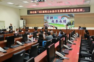
On the 21st of September, the Hsinchu county government held a “921 International Disaster Prevention Drill” at its Fire Bureau to coincide with National Disaster Prevention Day, with Director Sun Fuyou kicking off the international disaster prevention drill at the Hsinchu County Disaster Prevention and Resilience Center.
The international disaster prevention drill was organized by the Disaster Relief Foundation and supported by the Hsinchu County Government Fire Bureau as well as the Austrian Research Promotion Agency (FFG).
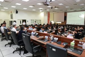
Present at the event were guests from the Austrian Institute of Technology, Austrian-based GeoVille, the University of Tokyo, the World Bank, the Girl Scouts of Taiwan, the Chinese Christian Relief Association, the National Science and Technology Center for Disaster Reduction, the Industrial Technology Research Institute, the National Central University and other institutions in addition to the Hsinchu County government and local councils. It was hoped that through international cooperation and exchanges on disaster prevention technologies, in addition to the Hsinchu County’s own ideas on disaster prevention, that Hsinchu County’s disaster prevention efforts could use both human knowledge and data, and improve the speed of disaster relief response.
The Hsinchu County Government Fire Director, Sun Fuyou, explained that Taiwan often suffers from natural disasters because of its geographical location, geological conditions and unique climatic conditions. The National Disaster Prevention Day was established to commemorate the massive “921 earthquake” which occurred 19 years ago.
Hsinchu county has also suffered disasters in past such as the Hsinchu and Taichung earthquake in 1935 which lead to disasters in towns and villages such as Zhudong, Emei and Baoshan, and Typhoon Aere in 2004 which caused the Wufeng village mudslide and other major disasters. The Hualian earthquake on February 6th and the September 23rd flood this year caused massive flooding in the south, and resulted in a large loss of life and property as well as industrial loss. This shows that disaster management strategy is an important issue that each level of government needs to continue to actively confront.
In response to these various disaster threats, in addition to the government strengthening its disaster prevention and relief systems, and through the interior ministry’s disaster prevention plan of deep plowing to strengthen the disaster prevention capabilities of the county and local councils, the disaster prevention sector has recently flourished due to the abundance of information-related equipment and talented personnel in Taiwan.
The innovative disaster relief company, GeoThings Inc., founded by the Industrial Technology Research Institute and supported by the Austrian Research Promotion Agency (FFG), collaborated with the Austrian Institute of Technology, expert satellite mapping consultants and the multi-national analytics company Geoville to launch a crowd satellite program (QuinJunSAT). It combines “wisdom of crowds”, network communications, the GeoBingAn cell phone app and high-resolution satellite mapping to rapidly assess disaster damage and acts as a reference for decision-making in disaster emergency response.
The international disaster drill simulated a magnitude 7.0 earthquake on the Hukou fault line. According to the predicted damage from the simulated disaster, the relatively seriously affected areas near the fault rupture surface were mainly Zhubei city, Hukou and Xinpu townships, with Hukou township on the epicenter the most seriously affected area. After the simulation of the earthquake, the county government opened a disaster response center in the fire bureau and immediately initiated damage predictions using high-resolution satellite map data together with international specialized teams. Furthermore, predicted disaster zones were published through GeoThings Inc.’s GeoBingAn app, and local councils were quickly mobilized to begin disaster investigation and reporting.
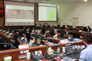
The disaster damage research was consolidated and matched with telemetry image interpretations for technical consolidation and modification by international experts and scholars, and also for subsequent disaster response and rescue planning. In addition to strengthening prevention and rescue capabilities, the drill on 921 National Disaster Prevention Day which studied disaster damage with international public and private sector cooperation also achieved its goal of promoting international exchanges and disaster prevention technologies.
Translation is based on the originaly posted article at source.